Blizzard stranded cars, stunted businesses and services

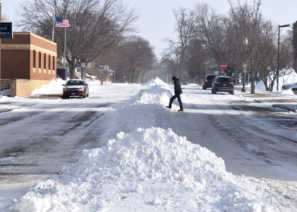
ABOVE: A pedestrian walks across the E. 1st Street in Fairmont, making their way over the center windrow, late Monday morning.
FAIRMONT – With up to five inches of snow and winds blowing that snow all around, conditions had businesses and services, street crews and meteorologists on notice from Sunday through Monday.
Some chose to open later than normal. Cornerstone Clinic and the Martin County Courthouse delayed opening until 9 a.m. due to the weather. Others, like the Giddy-Up Boutique, stayed closed on Monday. Those that opened had to contend with continued blowing snow Monday after the snow and wind on Sunday.
Fairmont Street Crew Foreman Travis Goerndt said for the most part, their clean-up operation went decently.
“Just a lot of vehicles stuck in the roadway,” he said. “Visibility was a challenge early on, but as the day went on, visibility got better. Some drifting here and there that we’ll monitor… Start cleaning up windrows in the downtown area tomorrow (Tuesday) morning.”
In his career, Goerndt said it was the most vehicles he had ever encountered getting stuck in the road during one storm.
While the cold was well below freezing on Monday, Goerndt said the sun was shining and it still had some power.
“It’ll burn through in spots, he said. “Shaded areas, not so much. As you get down, get the bare spot opened up on the pavement; it’ll start burning through.”
Overall, they used 17 different vehicles, from plow trucks to jeeps with plows, and 15 drivers. There were also two mechanics on hand to fix whatever issues could have popped up.
This, combined with the snowstorm at the end of November, has provided plenty of snow and poor conditions that had mostly stayed away the past couple of years. Regardless, Goerndt said by this point it feels like second nature.
“You tend to get a couple snowfall events a year,” he said. “Granted, they weren’t as big the last few years. It’s pretty much second nature for everybody to come in, do your thing, know what you’re doing, and do it as quick as a person can in a timely manner.”
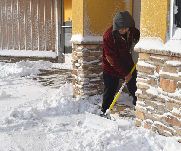
ABOVE: Dario Martin shovels snow off the sidewalk on Monday morning outside of El Agave Mexican Restaurant on Downtown Plaza in Fairmont.
As for what got us to this point, National Weather Service Meteorologist Ryan Dunleavy said it was two low-pressure systems that did the job.
“If we think about the way the lows and highs move across the country, there’s what we call a jet stream that they follow,” he said. “Sometimes you can have more than one jet stream. That’s what happened with this scenario is the two jet streams converged on each other on the other side of the Minnesota-Iowa border. That helped with the intensification.”
According to their tallies, snowfall totals reached between three to five inches across Martin County, and winds made it to 40 to 50 degrees.
On the temperature shock, going from 30s and 40s before the storm to well below zero after, Dunleavy said this is not very uncommon.
“Especially during the wintertime, you get all these systems,” he said. “Especially these clippers that come down from the north and west. They do tend to have those arctic air masses. I think especially this year it’s a little bit more noticeable because we’ve had a few more days where we’ve had warmer temperatures.”
As we head toward 2026, Dunleavy said it should be up and down in temperatures.
“We’ll warm up for (Tuesday) and then a little bit on Wednesday,” he said. “Then we cool off again. We’ll have a chilly start to the new year, but then we warm back up into the mid 20s and mid-teens for highs and lows after. We’ll be near average just after New Year’s.
There are some outside storm chances today and Wednesday. Dunleavy said today’s looks more like an issue for Wisconsin, and Wednesday’s is trending to be west of Minnesota. However, he said there’s still time for both to make a shift toward Minnesota’s southern border if conditions make it so.
Local News
Blizzard stranded cars, stunted businesses and services
After month-long pause, council moves on admin. vacancy
FAIRMONT— The Fairmont City Council had another special meeting on Monday to consider potential action on the ...
Watch for thin ice, aerators, on area lakes
CEYLON — I hope you all had a good Christmas and will have a grand 2026. The Helping Hands of Ceylon would like ...

Blue Earth business doing a major expansion
Bravo Zulu House smashing goals heading into 2026
Christmas tree disposal available as state watches for invasive species
FAIRMONT – When everything needs to be taken down, spots are available to safely dispose of natural Christmas ...